Jade Lake
When you choose to backpack to Jade Lake, expect the view to be hard earned. There are three possible access points. The shortest hike, about 21 miles RT, would be from Tucquala Meadows trailhead accessed from I-90; however you have to keep in mind that you will be driving 13 miles on a very rough dirt road to get there. Several very popular hikes commence here and you have to arrive very early to secure a parking spot. During weekends coming as early as 7:30 a.m. might mean you will be out of luck.
If you are not up for parking frenzy, you can choose trailheads accessed from Hwy 2. Tonga Ridge trailhead involves dirt road as well; however it is usually in decent shape. From here you are looking at roughly 23 miles RT.
Least amount of driving and most amount of hiking can be experienced by parking at Deception Pass Trailhead. There is only 1 mile of dirt road to be conquered to access the parking lot. This approach warranties 30 miles of hiking, 15 to the lake and 15 back. In the spirit of preparation for our PCT thru-hike next year we choose to start from this trailhead.

The first five miles lead through forested valley on a trail much steeper than we expected. Where we envisioned rising gently in the shade of the tall evergreens we are met by steep rocky stretches and where the trail lays flatter, great amount of mud spreads through its entire width. Deception Creek roars next to us. Sometimes we walk at its elevation, sometimes the trail takes us high above the creek bed but it’s thundering sound is with us for most of the distance. Along the way we pass several camp sites, one of them occupied. They look pleasant if you fancy a day of relaxing not too far from civilized world.
It takes us 2.5 hours to reach the first intersection. Deception Creek trail meets Tonga Ridge here. Just before we proceed further, we notice time marked on the ground, message from our friends Karel and Helena, who were not as ambitious as us and started at the higher trailhead. They are an hour ahead of us.

The trail keeps in the forest for which we are thankful. Above the trees the sun shines brightly, temperature was predicted to reach above 80 degrees, but the forest floor is shaded and cool and walking even though still uphill is much more pleasant in the shade than it would have been on the direct sun.
Right after Tonga Ridge intersection we have to cross a stream. This is our third major creek crossing but the first two were on a bridge. This one does not afford us the same luxury. It takes us a while to find the best way across. We make it dry hopping from rock to rock and then scrambling onto the steep bank on the other side. I’m thankful for the green belays that are plentiful.
Second creek crossing does not let us wait long. This time a sign posted on a tree gives us an option to ford or to use a footlog. Footlog it is; even though we have to walk over a small hill to get to it. The sight of the log surprises us. It’s a small tree trunk, one a swift current would easily carry away. It’s not the kind of crossing that usually get their own trail signs. But the path clearly heads for it. The placement of the log makes it little tricky to walk across but with help of both poles we make it without accident and then we have to scramble over huge tree trunks lying horizontally next to the stream.
“This is what I call a foot log,” I say when I climb over the biggest one of them all and just when I’m to slide off it, I see a surface flattened by human hand with grooves for traction on the other side. Sometimes in the past this was the advertised footlog. It’s mind blowing to imagine the force that washed it ashore in ninety degree angle to its original position.
There are more creek crossing further along the trail, less significant ones and all of them can be easily rock hopped keeping our feet dry and happy.
The next intersection is with a cutoff trail leading to PCT. It’s just a junction in the trees, not much to see around and so we grab a quick bite here and continue for the next stretch of our hike. After a short downhill the trail starts opening a little around us. We walk through meadows and again cross a stream several times. The path is mostly flat, and soft and enjoyable here.
When we bump into the next uphill, it’s steep but short and atop there is Deception Pass, junction of three trails – PCT, Deception Creek Trail and Clarice Lake Trail. From here we say goodbye to Deception Creek and start following route leading to Clarice Lake, now accompanied by our friends with whom we met at the pass.
There is many more people on the trail now. We are the only ones who came from Hwy 2, the others arrive huffing and puffing from Tucquala Meadows trailhead. We share the trail from now all the way to our destination.

At first there is a short up and then the trail drops. It goes down and down and down and I hope the down will end soon because tomorrow we will hike the hill in opposite direction. Finally the bottom comes. After crossing a shallow stream the trail bounces and we have to gain all the elevation we lost plus some more. Luckily only the very first part is steep, then the trail traverses a long hillside on a significantly gentler grade passing viewpoints where we spot Glacier Peak and there is a beautiful waterfall and berries grow within our reach. The hillside is in shade, it helps us to maintain good pace all the way to Marmot Lake.
For some Marmot Lake is a final destination, even our friends briefly consider spending their night here. Several people are swimming. It’s an inviting idea but we resist the temptation and push on.
Along the shore the path narrows, occasionally we have to climb over a tree or scale a short rocky outcrop. It drops us in a large talus field through where the way is marked by cairns. Here we meet an ongoing traffic, group of 4 youngsters heading back to Marmot Lake. They inform us that the scramble is tough and it will take us about two hours to reach the lake. It’s discouraging but our spirit is lifted soon when a faint path appears on our left side. It quickly vanishes in the boulders but then it reappears and this time it’s quite well defined and the ascent becomes much easier. In the end we lay our eyes on Jade lake less than an hour from the encounter.
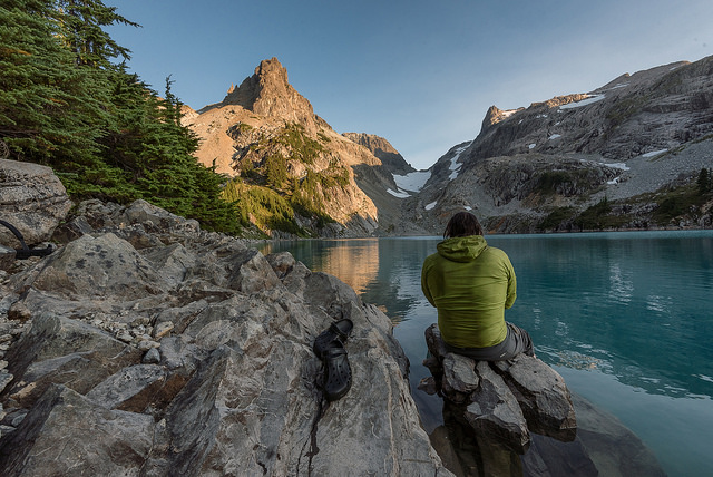
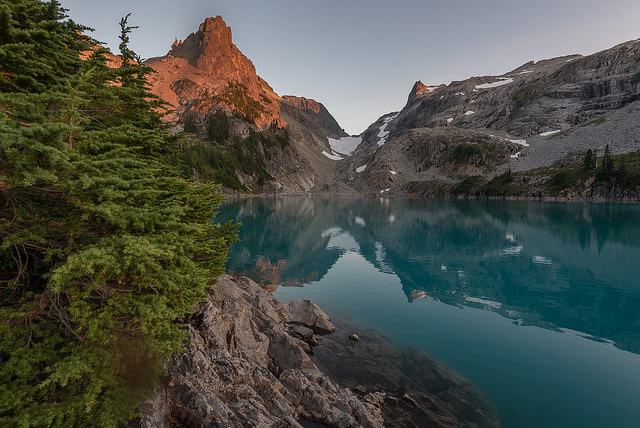
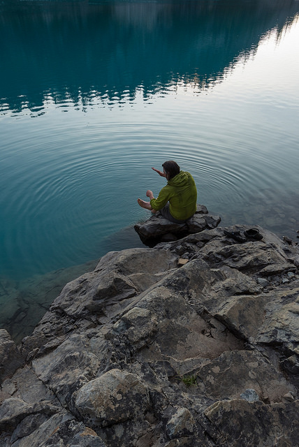
The color is what we notice first. Bright turquoise blue, suggesting the lake’s glacial origins. It’s nested in a rocky terrain with steep cliffs protecting its shore. Path continuous along the shoreline and beckons to explore towards Tin Can Gap. But for the climb to the gap we’ll have to return another day. Today we walked 15 miles already and all we fancy is finding a quiet spot along the rocky shore where we can enjoy our dinner and sunset and the calming sound of the water.
Hiked: 8/21/16 – 8/22/16
Distance: 29.2 miles RT
Elevation Gain: 6,347 ft

Trailhead Directions:
Access the Deception Pass trailhead from Highway 2. Drive east to mile marker 56.6, found between the Skykomish and Stevens Pass. Turn south onto Deception Creek Road (FR 6088), and continue for one mile to the trailhead.
Wow – beautiful photos!
LikeLiked by 1 person
You understand better why it is called the Jade Lake by looking at your picture ! Simply gorgeous!
LikeLiked by 1 person
Sure is a beautiful area. I’m looking forward to following you on your PCT adventure next year!
LikeLiked by 1 person
I am having trouble locating where the parking lot is near Deception Pass Trailhead. We are from Michigan so when we land in Seattle, pick up our rental car, we will need to use the GPS to get there. Do you know what the parking lot is called or suggestions on how to find this parking lot?
LikeLiked by 1 person
Drive on Hwy 2 east to mile marker 56.6, found between the Skykomish and Stevens Pass. Turn south onto Deception Creek Road (FR 6088), and continue for one mile to the trailhead.
LikeLike
Please also note that this is one of the trailheads the lake is accessible from. The more common approach is from Salmon La Sac trailhead. (The hike is shorter, less demanding but the road is quite horrible so unless you have high clearance vehicle, you’d have to drive very slow).
LikeLike