Vesper Peak
Layers and layers of rugged wilderness. That is what North Cascades stand for.
Four and half miles of bliss to a summit with incredible views. OK, maybe the bliss is just an invention of my imagination now since I’m down the mountain and my feet don’t feel the sharp ever present rocks anymore but the rugged trail that starts at second growth forest and will nearly immediately have you cross unabridged creeks among other obstacles definitely has a way to engrave a place in your memory that is not all about aches and pain.
From the moment the forest spits you, the trail heads more or less in the direction of Morning Star Peak and it looks as if it might even dead-end at its base but when you get there on a steep and rugged path, there is a sharp right turn and even steeper slope cresting at Headlee Pass. I love the ascent. It zig zags up steep narrow corridor and brings you to intimate proximity of the jagged knife edge ridges North Cascades are known for.
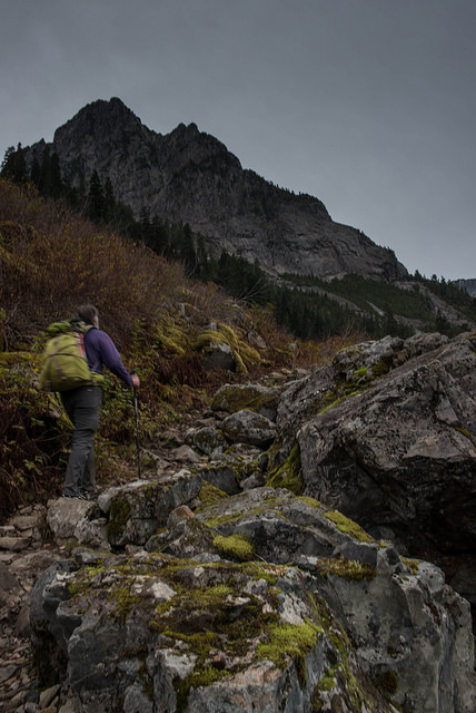
Making our way towards Morning Star
For some hikers Headlee Pass is enough of a destination but really it’s a shame to stop there. On the other side of the pass the trail traverses towards Vesper Lake. The trail eases in grade here and where it lacks in steepness it compensates in views. Impressive mass of Vesper Peak towers in front of you. To the side is the precipice of Sperry Peak. And if you turn Morning Star shines behind you. And if, by any chance, your neck started hurting from looking up to their majesties, there are also the long deep valleys carpeted in colors calling for your admiration. It’s not quite a stroll, you still need to watch your steps not to stub your toes on a boulder or trip over an occasional tree root but it’s probably the easiest part of the route.
Vesper Lake sits in a rocky bowl between Vesper and Sperry Peak in an alluring alpine environment with sparse vegetation. The water as it leaves the outlet is turquoise blue, pointing to the lakes glacier origin. For hikers the trail ends here. Those who are looking for more adventure can scramble either Vesper (Class 2) or Sperry (Class 3) Peaks from here.
For Vesper which is our destination, narrow path continues across the lake’s outlet stream. It quickly gains on intensity. Before you know it, you are overlooking the lake from a vertical distance of several hundred feet. And the views are to get better yet. But not before you tackle bushwhack through mediums sized shrub on a path that is not much more than a deep water eroded ditch. The vegetation often acts as belays here aiding you up or down steep steps.
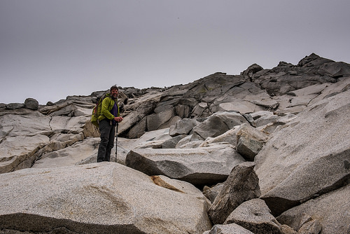
The last 500 vertical feet are gained on these large granite boulders and slabs.
The final stage of the scramble will take you on open granite slabs. Intuitively you will look towards a saddle to climber’s left above which there is short climb to the summit. The route; however takes you to the right where an easily gained ridgeline and cairns will guide you.
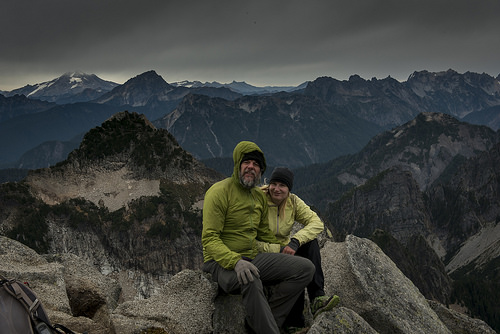
The summit is an extravaganza of 360 degree views. Enjoy them. They are well earned.
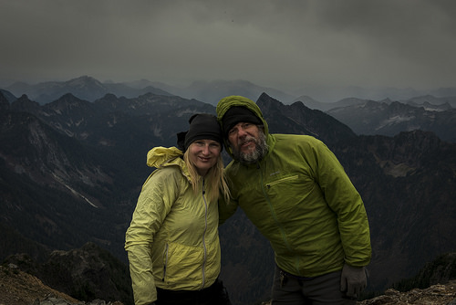
Made it. But unexpected store front chased us off after only about 5 minutes of summit time.
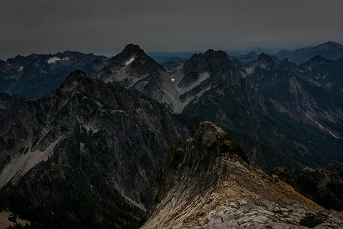
Amazing sights of the Cascade mountain range. We’ll be back to savor them under a better weather.
Hiked: 10/24/2015
Distance: 6.98 miles RT
Elevation Gain: 4,696 ft
DIRECTION:
From I-5, take exit 194 for Highway 2 towards Snohomish/Wenatchee. Drive for nearly 2 miles, then take the left exit for WA-204 E towards Lake Stevens for 2.5 miles. Turn left onto WA-9 N and drive for 1.7 miles, then turn right onto WA-92 E. After 1.5 miles on this road, arrive at a traffic circle and take the second exit to stay on WA-92 E.
After nearly 6 miles, arrive at a second traffic circle and take the second exit onto Quarry Road. Proceed through two more traffic circles, always staying on Quarry Road, before arriving at an intersection, where you will turn left onto the Mountain Loop Highway (Hwy 530). Drive for 27.5 miles and then make a right onto Forest Road 4065. Drive about 2.5 miles to the end of this road to the trailhead.
What breathtaking sights!
LikeLiked by 1 person
That is really a spectacular view – too bad the storm front was approaching fast so you didn’t have time to enjoy it longer!
LikeLiked by 1 person
Wow, there was NO snow up there!! We did Del Campo earlier in the season and we could see Vesper and it did not look like that. Holy cow. Awesome pictures, it is totally on my to do list!
LikeLiked by 2 people
Beautiful views but looks tough :-)
LikeLike
Amazing photos. It looks like such an awesome trek. There are so many great hiking opportunities in that area. I’ve gotta get outta Southern California!
LikeLike