Orcas Island

View from a street in Eastsound
Orcas Island, part of the San Juan Islands in Washington State, is a popular tourist destination. Most of the island’s 57 square miles are rural and hilly, with curving roads that wind through forests and fields and past artists’ studios. Once in a while they will lead you through a charming coastal village, a great stop to see more art and enjoy a snack or a full meal if you so desire.
Many visitors come to enjoy the islands slower pace of life. Others are lured by the numerous possibilities of outdoor recreation. Swimming and kayaking are among popular water sports. On the ground there are miles of trails for hiking, mountain biking and some that are also open to horseback riding.
To get to the island I board ferry in Anacortes. Anacortes is known for the Washington State Ferries dock and terminal serving Lopez Island, Shaw Island, Orcas Island, and San Juan Island, as well Vancouver Island in Canada. The ride to Orcas costs $38.00 for return ticket and it is an hour long. At mean high tide, there are over 400 islands and rocks in the archipelago, 128 of which are named, and some of them come to view shortly after leaving Anacortes. It is a pleasant ride.
The ferry makes a quick stop at Shaw Island which is the smallest of the San Juan Islands serviced by Washington State Ferry System. Vehicles are not allowed to disembark here. It is strictly a walk in/bike in stop on an island with a general store (opened May – September) and a post office but no hotels or restaurants. It’s accessibility makes it a popular day trip destination for those vacationing on one of the bigger islands.
Ten minutes later we arrive at Orcas. It’s shortly before sunset. The light is soft and the descending sun dresses clouds in pink hues. I have a reservation at Lodge on Orcas Island. The property is located in the middle of the island, a distance that can be driven in approximately 25 minutes. By the time I get there the sunset magic has faded and I retreat in my room to finalize plan for the next couple of days.
At 2,410 ft, Mount Constitution is the highest point in the San Juan Islands. On a clear day it delivers panoramic views of the surrounding islands and the Cascade Mountain Range including Mt. Baker and Mt. Rainier. I wake up to a cacophony of rain drops beating on my window and in an instant I know that the sunrise I envisioned watching from the top is not going to happen so I change my plan and head to Eastsound, a hamlet about a mile from my lodging, where I stop for a breakfast at Brown Bear Baking. The prices are on a steeper side but if you’re looking for fresh out of the oven pastries, this is the place to go. I have chocolate croissant that melts on my tongue accompanied by a cup of hot chocolate and I take a scone with me as a hiking snack.

Delicious breakfast
According to the forecast the weather should improve later in the morning. I linger in Eastsound for a while longer hoping the clouds would lift. I stroll along the main street which is dotted with small storefronts offering variety of souvenirs, art, and handmade clothing and I also check out the beach. When the sun peeks from the clouds I decide to head to Moran State Park from where I can commence my hike of Mt. Constitution just to find out that the weather has not cleared at this part of the island. The upper part of the mountain is shrouded in clouds and the clouds are dark and threaten to precipitate. It’s much nicer down by the water. And for a pleasant stroll by the water I choose to visit Obstruction Pass State Park. It’s located on the south tip of the island just past the town of Olga. To drive there I leave the paved road for the first time during my stay.
Obstruction Pass State Park offers public access to a 150 yards of saltwater beach. To reach it one must take a hike through a lush forest of evergreens. The forest floor is carpeted by stinging nettle, plant that has a long history of use as a medicine, as a food source and as a source of fibre. The main path is only 0.6 mile long and with minimal elevation gain it is a very pleasant walk.There is a side trail available for the more adventurous ones which is uneven, rocky and sometimes close to the cliffs. But it delivers some very nice views. From the beach which is lined by beautiful madrona trees one can retract their steps or take the 0.9 mile high path back to the parking lot. I chose the loop option and I am surrounded by second growth forest full of beautiful mossy trees that look as though fairies dance on them during moonlit nights.
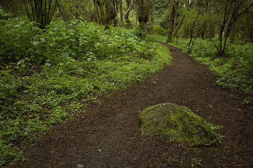
Path heading through Obstruction Pass State Park

Beautiful Madrona trees

Enchanted forest of Obstruction Pass State Park
The clouds are still hugging the summit of Mt. Constitution but generally the conditions improved. I drive the 5.5 miles back to Moran State Park. There are several possible trailheads for the hike. I choose the one on Olga Road, just across the day use area on Cascade Lake. From here it is 4.3 miles to the summit. Other trailheads are higher up along the paved summit road and offer a shorter hike.
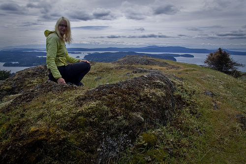
From the parking lot I start heading up wide gravel path alongside a small creek. I watch the stream making its way among moss covered rocks. It’s simple yet such a pretty scene typical to the Pacific NW. The path leaves the creek shortly. It narrows to a size of a trail which slowly but steadily gains elevation. Even without the water bubbling by there is still plenty to see. There is a variety of forest greens and among them an occasional wildflower. You will walk past a lake and later you will stumble upon a simple wooden shelter. The last part, once the trail crosses the summit road, is my favorite. The forest thins and the trees stand further apart allowing for views to sneak in. The trail wraps around the mountain and the higher it goes the more extensive the views become. Today I can see many islands and beautiful cloud formations in the sky above them. The grand view is, of course, from the summit, from a small stone observation tower built in 1936. Inside the tower, displays tell the story of the tower’s construction. You can also read about Robert Moran here, a former Seattle mayor who donated the land and worked towards the development of the park.

Atop Mount Constitution
If there is a downside to Orcas Island it is its lack of public beaches. When I get back from my hike, I have time to catch a sunset and being on an island, a sunset on a beach seems fitting. I’m surprised to find out there are few places I can do so. I have already visited Obstruction Pass State Park. The other beach I can get to is off N Beach Road. It is a small but nice beach with a view of Mt. Baker. I get there just in time to witness the sun dipping below the horizon. The sky turns from red to pink and after that the colors fade to blue before the darkness takes over.

Sunset on the beach
In the morning I stop at Brown Bear Baking once again and pick up bear claw for breakfast and croissant for hiking. Today I’m going to hike around Turtleback Mountain Preserve on the west side of the island. There are two possible starting points. The North Trailhead on Crow Valley Road offers traditional Northwest hike through old growth forest with a view of Waldron Island. From the South net of trails is available including those crossing unique Garry Oak habitat and those offering views of farmlands.
My route starts on the South Trail which I like a lot for the beautiful trees and ferns that can be seen here. In less then half mile it takes me to an intersection with Lost Oak Trail. I follow it for another mostly uphill half mile where it connects with Ridge Trail. The scenery changes here. The trail widens and by the time it drops me off at center Loop trail it is obvious that I am on an old road. Grass claims its place among the gravel but the tire tread is still quite obvious. There are wild strawberries blooming along the road in an amount I have not seen anywhere else in Washington State. And I also notice the birds. They are everywhere. Their song is loud and cheers me up on my way.

South Trail – part of the route to the top of Turtleback Mountain
This road-to-trail takes me via small section of Raven Ridge Trail to Waldron Overlook from where as the name suggest there is a nice view of Waldron Island. If I continued on the road I would have gotten all the way to the North Trailhead. Instead I take a spur trail to the summit of Turtleback Mountain. Here I am back on trail. The path is narrow and soft under my feet and the color of the dirt contrasts with the bright spring greens. When I think things can get any prettier the trail takes me through a mossy rock garden and onto the summit plateau from where the views are breathtaking.

Fresh greenery along the trail to the top of Turtleback Mountain
Had the mountaintop all for myself
On the way back I retrace my steps to where Ridge Trail intersects with Lost Oak Trail. There is a third trail commencing from here which goes to Ship Peak and then loops back to South Trail and the parking lot via Morning Ridge. The vistas from Ship Peak include farmlands and roads cris crossing the fields. Later I am descending on a bright open ridge. The views of the world bathing in the first morning light must be breathtaking from here. I can also admire the beauty of old Garry Oaks here, attractive trees with thick grooved greyish bark and deeply lobed bright green leaves. On the ground long leafy vine plant is presently blooming. It covers the slope in numerous places and its scent reminds me of honey.
After descending from Turtleback Mountain, I have just enough time to drive back to Orcas where I line up for the ferry and enjoy 30 minutes by the water before my 5:15 p.m. ferry arrives and takes me home.

Morning Ridge Trail

I never found out name of this plant. It was plentiful along the open slopes and very fragrant.
Visited: 4/25/15 – 4/26/15
Miles Hiked:
Mount Constitution 8.6 RT
Turtleback Mountain: 9.2 miles
Directions: If you are coming by car and taking a Washington State Ferry, the mainland terminal which serves the San Juan’s is located in Anacortes, Washington, 80 miles northwest of Seattle. Follow Interstate highway I-5 north from Seattle, take Exit 230 and follow Highway 20 west to Anacortes. Once you are in Anacortes, take a left on 12th Street (Safeway market will be on the right), then follow the signs to the ferry terminal and ticketing booths (just 5 minutes away).
Ferry can and should be reserved ahead of time, especially for summer months and weekends. You can make your reservation here:
http://www.wsdot.wa.gov/Ferries/TakeaFerry
Orca Island looks like a delightful place for a weekend getaway! The pictures from you hikes from this trip are beautiful. Love the views with the ocean and scattered island. The are reminds me of the area around Vancouver Island that we visited last summer. Looks like there are lots of opportunities for kayaking as well?
LikeLike
We’ve only been on San Juan very briefly, as a stop on our orca spotting tour that departed from Seattle.
After seeing your post, I’d love to go back and explore the archipelagos, very charming looking indeed!
LikeLiked by 1 person
My husband and I fell in love with Orcas Island the moment we drove off the ferry. We enjoyed hiking at both Mount Constitution and Turtleback Mountain as well. We also really enjoyed exploring the trails throughout Moran State Park.
LikeLiked by 1 person
The Judd Cove Preserve has a small and scenic beach you can easily access off the Horseshoe Highway just before Eastsound. It has a very short loop hike, too.
LikeLiked by 1 person