Blanca Lake

Overlooking Blanca Lake
33 switchbacks through a second growth forest lead to a ridge and a sub alpine meadow and then the trail drops to a glacier fed lake. This is how in a very short sentence one could summarize the hike to Blanca Lake. But there is not enough room in one sentence to describe the deep greens of the woods, the way beams of sunlight penetrate the canopy of evergreens before they touch the forest floor or the refreshing sound of a creek bubbling by. There is not enough room in one sentence to point out the scent of lupines carried by a mountain breeze or their vibrant colors against a stormy sky. And there is for sure not enough room in one sentence to capture the moment when your eyes meet the turquoise water of Blanca Lake.
The trail is usually accessible in early July and remains opened until the snowfall in October or November. During this time you will find a well maintained path that is easy to follow but not so easy to climb. There is little time for warm up. The trail gains 2700 ft of elevation within the first 3 miles. But it’s effort you won’t regret. Once you break from the forest, the views are wonderful and depending on a month you hike, you will also be surrounded by a plethora of wildflowers or a good harvest of berries up there.

Down by the lake

Lunch spot with a view
The last half mile slopes downhill, and yes, you will have to climb the 600 ft back up on your way out but if this steep and rocky section caused you any hardship, it will be forgotten once the view of the stunning alpine lake surrounded by rugged peaks opens in front of you.
We have a rare opportunity to visit Blanca Lake in the beginning of April. The winter has been weak and a good portion of the trail is melted out already. The snow starts shortly before hitting the ridge and there is a well worn path we can follow without a need for snowshoes. I like the crunch of the powder under my feet. We didn’t have a chance to enjoy it much this year. In the meadow the snow feels fresh and light and I step out of the packed trail for a while and break my own path through the fluffy blanket.
On the downhill the trail is narrow with wet rocks and roots sticking out of the compacted snow. In short, everything is very slippery and without traction it’s hard to find a good purchase. Even Dave, who is usually quite stubborn when it comes to traction, puts on his microspikes.
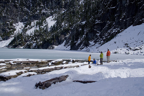
Blanca Lake is a popular destination. Don’t expect much solitude unless you come very early or if you are staying overnight (space is very limited for overnight stay). We are lucky to enjoy the area with only two other people around. Many more are coming but by then we are already on our way home.
Shoreline with little bit of camping space

Trail above Blanca Lake
DIRECTIONS:
**Access the trailhead via FR 65, not the Skykomish River Road, due to washouts west of Garland Mineral Spring.**
Take US Hwy 2 east from Monroe to just past the town of Skykomish. Turn left on to FR 65, more clearly marked as Beckler River Road, and drive past the Beckler River Campground. Take FR 65 for 15 miles all the way to the intersection of FR 63 and the private Garland Mineral Springs Road. Take a right on FR 63 and proceed about 2 miles. The trailhead is on a small spur road to the left, up another small hill.
Hiked: 4/5/2015
Distance: 7.5 miles
Elevation Gain: 3755 ft
Wow this is very beautiful indeed. I’ve googled images of Blanca Lake in other seasons, it’s a knock out!
LikeLiked by 1 person
I can understand why it’s a popular destination, it’s gorgeous !
LikeLiked by 1 person
Wow, what a stunning place! I’m sure it was an amazing trip.
LikeLike
What a great scenery. Love all the fallen trees/ drift wood on the shoreline. Quite an elevation gain in that first section!
LikeLike
lovely pictures, and snow… beautiful! :)
LikeLiked by 1 person
I’m visiting the PNW again in July and this is definitely on my to do list!
LikeLiked by 1 person