Laugavegur Day 4 – Emstrur (Botnar) to Thorsmork
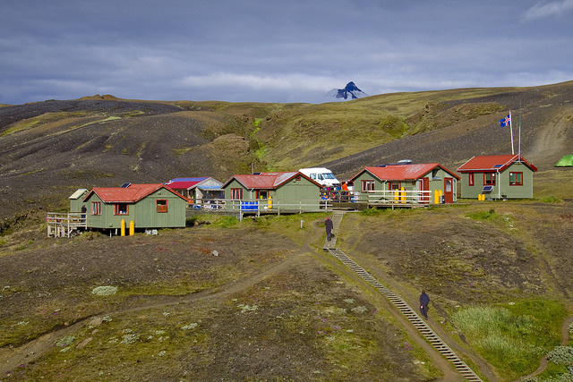
Emstrur(Botnar) in the morning
Distance: 9.5 miles
There are two different types of trekkers on the trail. Those, who pack their belonging every morning and carry them on their backs to the next destination. Then there are those who pack all their belongings every morning and leave them behind for a supporting company to pick them up and transport them to the next hut in super jeeps while they stroll along the trail only with a small daypack. You can, of course, easily tell the two types apart on the trail but when the difference is even more magnified is during mealtimes. Lamb chops, boiled potatoes, pots of rice, fresh fruit, cans of beans, loafs of bread and of course beer and wine, those are staples of those who don’t have to carry their food on their backs. Their meals are served on plates and they use real silverware.
Today there is a couple making some sort of flatbread while another group grills sausages. I watch them as I pour boiling water into a ziplock bag and shake it, hoping in next few minutes my dehydrated breakfast will be ready for consumption. I’m not complaining about our diet, we spent hours dehydrating and packing our own recipes and usually these meals make other hikers jealous but today when the smell of sausages reaches my nose, I have to admit a little bit of an entree envy myself.

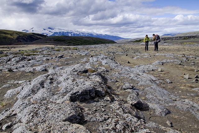
Wild Boar Rock
We have another easier day ahead of us, dropping approximately 980 feet over 9.5 miles. I’m eager to start. It’s not because of the scenery, or pleasant weather though. Soon after leaving camp, we should arrive at a bridge that is said to be dangerous, especially for people who are afraid of heights. Words of ropes and chains were uttered. It won’t be until after I cross this bridge when I will be able to relax and appreciate the beauty that surrounds me.
Walking out of camp, requires just like yesterday a short uphill and then there is a stretch of flat land crossed by multiple streams. None of them we have to wade. The water is low. Rocks peak above the surface and we can easily hop from one to another to make it to the other side.
The infamous bridge awaits us after a short scramble down a rocky cliff. This is where the rope is provided to aid the descent (or ascent if you are hiking the trail in the opposite direction). The easiest way down is to hold onto the rope and downclimb facing the rock. This obstacle can be overcome in several small steps.
First glance at the bridge tells me my worries were in vain. In my imagination it was a suspension bridge swinging high above the raging water flow, or a narrow wood plank with no railings. It’s neither. The bridge is a solid construction with railings wide enough for two people to pass each other if needed to be. It was built in 1988 after the original bridge from 1979 was swept away during a flood. If you stop in the middle, the view of the river rushing through the tight space in between the rugged canyon walls is quite spectacular.
On the other side a chain is bolted into the rock where the trail makes a brief but steep ascent out of the canyon. It can be helpful when the ground is wet and slippery but today we really have no use for it.
The scenery is even more varied than yesterday. We are dropping through colorful gorges, traversing sandy stretches, and once we near Ljosa River larger vegetation returns – grass, flowers, brush, and for the first time during this trek, we are surrounded by trees.
Strolling along the trail provided plenty of opportunities for a chat with fellow hikers.
It’s too tempting to take the pack off and sit on the soft grassy bank of the river where the sound of the water meets the one of a breeze rustling through the crowns of the trees. The sun is warm and we’re feeling lazy and so we sit for a short break that turns into a longer one and longer one yet and in the end we spend good hour here doing nothing at all, and it feels darn good.
Climb awaits us when we decide to get on a move again. It’s steep but just like any other uphill we experienced along the trail, it is not too long. We are treated to great views from the top of Kapa, one of them into a valley through which a river snakes its way forward. Pronga is the last river we have to wade. It is much wider than the rivers we waded in last three days but the flow is mild and the water reaches just inches above our ankles. On a day like today it’s water offers a welcome refreshment.
According to our guidebook it should be a smooth sailing all the way to Thorsmork once we waded the river. It’s not entirely true as another uphill stands between us and the campground. Neither our legs nor our mind braced themselves for the ascend and it feels long and tiring. But the scenery we can’t complain about. Everything is so lush and wildflowers bloom in abundance. Across the valley there is a ridge we will have to gain tomorrow. We try to find the trail, or at least a possibility of it but our imagination fails. It might be that the perspective plays tricks on us, making the slope appear steep and impenetrable, or perhaps the route is hidden behind one of the closer features. Either way we will get quite high up and if the day is anything like today, there will be lots of ohs and ahs over the views, I’m sure.

I see a great lunch spot here.
There are three camps in Thorsmork. Volcano Huts with natural hot pool, sauna and a restaurant are the Hilton of camping here. Campsites as well as cute little cabins are available to guests. On the other end of the Langidalur valley Basar camp offers more solitude. It’s grounds hold tent sites but largely it rocky ground seems to be suited more for car camping. Making a compromise, we chose the Icelandic Touring Association Hut and campsites. It’s a great choice. The location, just a stone’s throw from river Krossa, is fabulous and the soft grassy sites could not be more comfortable. Volcano Huts are within a 30 minute walk if one feels the need to enjoy their tasty but pricey (4,500 kronas as of 8/2015) buffet dinner. For those not hungry for a large meal but there is a small store directly in the ITA camp. Refreshments including beer can be found here.
Thorsmok is the official terminus of Laugavegur trail. From here you can take a bus back to Reykjavik or other popular destinations around the country. The buses run several times a day and most will have wi-fi on board. Reservations are not required.
Thhis was a lovely blog post
LikeLike