South Sister Cloud Show

The clouds were simply amazing
“I really hope we can go backpacking this weekend,” I say as I flip through weather forecast for four or five destinations we had on mind.
The prognosis is not good. Summer seems to have ended in Washington with the last day of August and we are headed for a wet Labor Day.
The closest pocket of nicer weather is 7 hours away around Bend, OR. There are several places worth exploring close to Bend, the one that immediately jumps on my mind is South Sister, one of Oregon’s volcanos, standing over 10,000 ft tall.
It’s been on my list for a while and with slight chance of snow showers on Saturday followed by two days of sunshine, it’s our best option.

South Sister above Green Lakes
Dave puts a quick call to Aaron who agrees to join us if we are up for a Green Lakes approach, slightly longer than the traditional Moraine Lake route but with a scenic base camp located in a basin between South Sister and Broken Top, picturesque remnant of yet another volcanic peak.
Green Lakes turns to be a better choice for one another reason. We’re not the only ones in a search of sunshine and the trailhead is packed. From a local ranger on duty we learn that the sites around Green Lakes likely will be taken but there is disbursed camping allowed in the forest above the lake and we have a better chance to find a spot there than we would have had around Moraine Lake.

Milky Way above our camp site
The trailhead is overflowing and we end up parking on a shoulder of the road with many others. Luckily the Rangers don’t have a problem with that and at 1:00 p.m. we are ready to hit the trail.
The trail raises gently along a bubbling creek. It’s a pleasant walk with an occasional cascade or a small waterfall coming in a view and not much uphill. We only have 1,200 ft to gain in 4.5 miles. The hardest part of day one is for sure looking for a place to camp.
There is another Ranger guarding the entrance of the Green Lakes. He points us in direction where a site or two might be still available and tells us how to access disbursed camping area if we don’t have any luck securing one of the lake sites.

Small green cirque lake bellow Lewis Glacier
What’s nice is that the sites are spread around the lake and ensure a good degree of privacy. This also means that there is great deal of walking involved in checking them out. Just as we expected we find every one on our way taken. We’re ready to head to the disbursed camping area when I get lucky and score the very last vacant site in the lake’s vicinity.
Large cloud covers the top of the volcano and when the sun dips down we can feel unseasonal chill but the forecasted snow does not make an appearance. The cloud cover dissipates after the darkness takes over and our bedtime show includes watching Milky Way and satellites crossing the nighttime sky.

Upper slope of South Sister

Arrived at the rim
We don’t feel the need to get up extra early the next morning. Our 8:00 a.m. wake up time allows for the first rays of sunshine to touch our site and it’s warm enough by the time we eat our breakfast that we don’t need to be bundled in all the layers we brought.
I’m glad we opted for a later start. Within the first 10 minutes our route crossed a creek which we have to wade, something I would not be happy about if we stood here an hour earlier.
After the creek crossing our route skirts an edge of a lava flow and at the end it’s possible to pick up a faint path leading up a hill. The path becomes more pronounced higher up and for a while it’s easy to follow. Eventually we loose it on a slope of scattered rocks and loose dirt. Once in a while we pick it up again but it’s definitely not as obvious as the description on Summit Post made it sound.

Dave tagging the summit
The reason behind it is simple. We are not on the main path. There are cairns here and at one point we walk by an abandoned wand but the main path is on the opposite side of the creek than we are. We discover the truth when we see couple of climbers descending that way.
At this point it makes sense to cross the creek and continue up on now much better tread. Within next 30 minutes the path reaches junction with the more traditional Moraine Lake route. This intersection seems to be the popular place to take a break before the summit push. Many hikers enjoy their snack here. The bright colors of their gear contrast with the increasing amount of greyness that now frequently conceal the views.

Compulsory summit shot
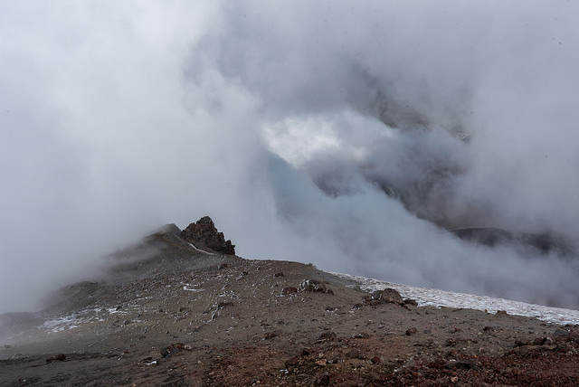
The weather deteriorates even more once we set out for the summit. It’s not as windy as it appeared from lower down but the clouds are getting thicker and thicker and by the time we climb the switchbacks and reach the rim it’s all milky around us and we are lucky to see to the true summit which is directly across the crater.
Once in a while the clouds partially break. It’s like looking through a narrow window into the world bellow us. These views are welcome though they often do not last more than few seconds.
But even the clouds have they magic. They lend the summit an appearance of a foreign, far away place, desolate and unforgiving. Place that can be enjoyed for its own unique beauty.

True summit of South Sister

Summit view
We hang around for a while, hoping the conditions would improve but when an hour passes without a change we give up and after crossing a snowfield in the middle of the crater we head down not seeing far ahead of us.
Sunshine eventually makes an appearance. It happens just when we return to the Moraine Lake intersection and it shines brightly for the rest of the day.
Did I mention the clouds were amazing
The evening is cold again and during the night I once wake up shivering in my sleeping bag. I wrap it tighter around my shoulders and soon I’m comfortably warm again.
I understand when the morning wakes us to a layer of shimmering frost. It’s beautiful and daunting at the same time. Fall is inevitably here and all I can do is to hope we’ll have the opportunity to enjoy few more overnight adventures before the rainy season starts.

Inside the crater
Hiked: 9/3/2016 – 9/5/2016
Distance: 15.5 miles RT + camp hunting and exploring appr. 1.5 miles
Elevation Gain: 5,000 ft
Driving Directions: Drive 25.8 miles west of Bend on the Cascade Lakes Highway. Turn into Green Lakes and Soda Creek trailhead.

Frosty morning at Green Lake
Great post! I really enjoy reading your stories and looking at the pictures. What camera/lens setup do you use to capture the Milky Way and all the other breathtaking views?
LikeLiked by 1 person
I’m shooting with Nikon D750. It’s a great camera for landscape photography. I have Nikkor 24-70 mm and Rokinon 14 mm lenses for it.
LikeLike
Great story. I spent a lot of time in Oregon (went to the U of O and taught there later) and climbed a lot in both the Cascades and at Smith, among other places. This is a nice memory of when I took groups up there for Eugene Parks and Rec (I was a guide for them for a while).
Keep up the great hiking and posting.
LikeLiked by 1 person
What an amazing scenery to hike in – and yes – the clouds look amazing! 🙂
LikeLiked by 1 person
Amazing landscape ! beautiful colours ! Wow, what an amazing backpacking trip 🙂 Thanks for sharing with us
LikeLiked by 1 person
Great pics! I did the hike years ago, it’s quite a slog at the top!
LikeLiked by 1 person