Tuck & Robin & Granite Mountain

It’s the last weekend of August, technically still summer but high in the Cascade Mountains the meadows are already dressed in the color of autumn and the morning air is crisp and it bites the skin. So today for the first time since summer has arrived we leave the trailhead with an extra layer on.
The trail starts on an easy grade, it’s mostly flat and gentle on our feet. Our pace is good but we could go even faster, if only the trail wasn’t lined by thimbleberries. They are ripe and sweet and often one bush produces three or four berries on one branch. We can’t simply pass them. So we make frequent stops to pick.

Four miles later a view of Hayes Lake opens in front of us. It’s a nice lake nested in a valley with view of Cathedral Rock. Many people camp along the shore and many of them claim their plan is to continue to Robin Lake today. It seems like we won’t lack company.
After Hayes Lake the trail steepens considerably. It even makes few switchbacks as it gains its way to Deception Pass. We don’t have to go that far. Turn off for Tuck & Robin Lakes comes within a mile after leaving the lake and it is here where the trail starts being really interesting.
The tread is not always stable here and many of the steep sections are gained on loose sandy dirt that has a great tendency to slip under our feet. The dust is ever present. It tickles and makes us sneeze. Often I have to walk several feet behind Dave if I want to indulge in breathing grit free air. But at least we are on a trail, one that is easy to follow and except for rare step over an insignificant downfall does not lay many obstacles in our way.

We can’t say the same once we leave Tuck Lake. A scramble more than a trail is is now that often relies on cairns to lead the way. Luckily we get off route only once and realize it before getting in trouble. Sections where we have to use our hands to pull ourselves up rocks or reach for a support of a green belay are frequent. It’s slow going but it’s easy scrambling with minimal exposure and even though it’s quite tiring, we are having fun.
Many tents are already set up along the shore. Only one group passed us so the others either came yesterday or started ahead of us. I don’t even want to imagine what time they had to leave their homes. Dave and I were up and going at 4:00 a.m.

One of the last sites on the shore of upper Robin Lake becomes our home for tonight. It has a view of the lake as well as several of our neighbors but we knew how popular this area has become in last few years and we did not expect solitude.
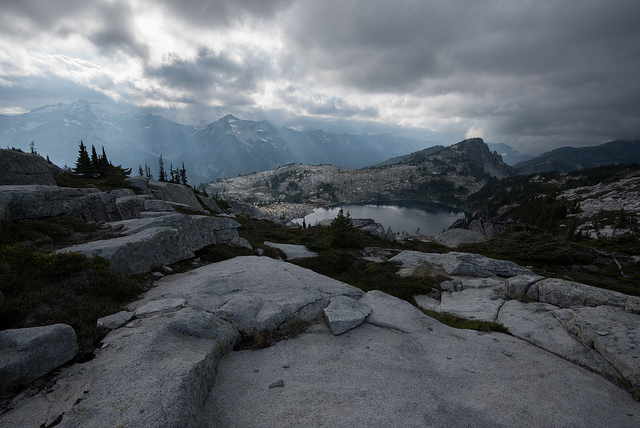
There are two peak in the basin that offers extensive views to those who still have some energy left after they get here. We climbed Trico few years ago and today our goal is the higher of the two, Granite Mountain but at first we are little hesitant to give it a go. Promised sunshine did not make an appearance and instead the nature sends dense dark clouds looming too close above our heads and several brief rain showers as well.

In the end we take advantage of a weather window during which it stops raining. To climb Granite Mountain we have to gain a ridge that starts between upper and lower Robin Lakes first. It’s relatively easy task, little bit of huffing and puffing and we are on the top.
Views are incredible here and if you are not up for scrambling this is a great destination on its own.
Our trip does not finish here. We make it down an adventurous hillside with few class 3 sections that are exposed enough to make me nervous but we make it down safely and the then rest of the way to Granite Mountain is a pleasure of terrain that is not too demanding and has excellent 360 degree views.
My heart skips a beat everytime I look in the direction of the slope we climbed down. No matter what angle I see it from, it’s downright scary. Luckily we don’t have to return the same way. Loop option is available and after summiting Granite Mountain we simply continue walking the loop, letting an easy path to lead the way. I really like this type of alpine terrain. Rock gardens, meadows of heather, some blueberries and a small amount of trees dotting the landscape but not concealing he views. It’s breathtaking.
The trail eventually takes us back to camp. Just in time for dinner. Tonight we test our new set up – snowpeak stove with lightweight titanium pot and a caldera cone to shield the wind. It’s OK. Not perfect. We’ll have to make some fine tuning to prevent the cone to slip off the pot so easily and hopefully then the setup will be working fine.


Hiked: 8/27/2016 – 8/28/2016
Distance: 18.7 miles RT
Elevation Gain: 4,276 ft


Trailhead Directions:
From I-90 take exit 80. Drive north on SR-903 to Salmon la Sac. Fork right and continue up Cle Elum Valley Road (FR-4330) for 12 rough miles to the trailhead.
Just beautiful!
LikeLiked by 1 person
Beautiful vistas but the climbing part looks scary!
LikeLiked by 1 person